REIA  /  Cumulative effects mapping

Every project looks small. The sum of them does not.

Canada assesses development one project at a time. The land experiences all of it at once, for decades, and nobody is required to add it up. Cumulative effects mapping is how a Nation adds it up for itself.

The structural problem

A gap that is a data problem before it is a legal one.

A wellpad is approved. It is small, and the assessment says so, correctly. Then a road to reach it. Then a cutline, a borrow pit, a transmission spur, a camp. Each one is assessed on its own, each one is genuinely minor, and each one is approved.

Forty years later the territory is crossed by thousands of them. No single decision was wrong on its own terms. The outcome is that a Nation can no longer meaningfully do the things its treaty guarantees.

Closing that gap requires somebody to hold the whole picture. Historically nobody did, because assembling it meant tracing every footprint across decades of imagery by hand. That is the part we are automating.
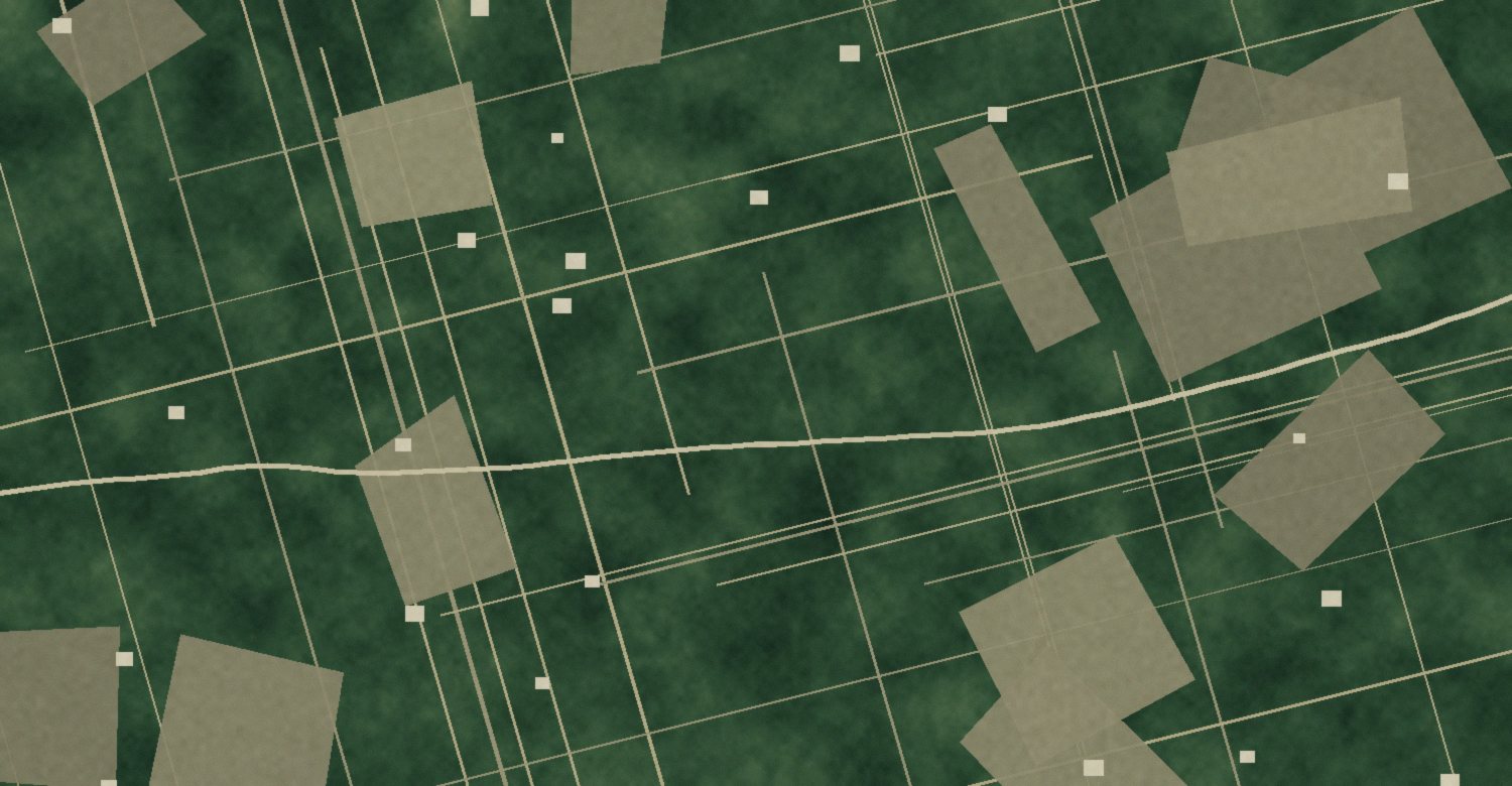
Boreal terrain crossed by straight seismic lines with cutblocks, an access road and wellsite pads Seismic lines, cutblocks, an access road and wellsite pads on a single stretch of boreal land. Every one of these was permitted separately.

Straight to it

You have probably lived at least one of these.

Five things that happen to a lands office when nobody is holding the whole picture.

A referral came in with thirty days on it, and you answered it with whatever could be found in an afternoon.

You are being consulted on the fifteenth project in the same watershed, and nobody has ever added the first fourteen together.

A proponent's assessment says the impact is negligible, and taken on its own it probably is.

Somebody asked how much of the territory is already disturbed and the best answer available was an estimate.

You have agreed to things you would have refused, if you could have seen the whole picture at the time.

Each of those is the same missing thing: nobody is required to add it up, so nobody does, and the Nation carries the result.

Why it matters now

A Canadian court has already said this counts.

In Yahey v British Columbia, decided 29 June 2021, the BC Supreme Court found that the Province had breached Treaty 8 with Blueberry River First Nations. It was the first time a Canadian court found treaty infringement from the cumulative effect of industrial development rather than from any single project.

The Court held that the Province had taken up so much land that Blueberry could no longer meaningfully exercise its treaty rights, and rejected the argument that infringement only occurs once no ability to exercise a right remains. Rights that are significantly diminished are infringed.

That reasoning turns a measurement into a question of law. How much of the territory is disturbed, how it got that way, and over what period, are now facts that carry weight. They are also facts that most Nations have no independent way to establish.

The evidence has to exist before the argument does. Assembling it afterward is how Nations lose years.

How it is built

Public data, assembled for one territory.

Almost every input is already free and already public. What has never existed is the assembly: all of it, for your territory, across the whole period, in one place, held by you.

Inputs

Registries, footprint layers and imagery

Provincial and federal permit and tenure registries, published human footprint datasets, forestry and energy disclosures, road networks, and satellite imagery going back to the Landsat archive. Community knowledge sets what matters and where not to look, and is never converted into data.

Public registriesLandsat archiveSentinel-2Sentinel-1 SAR
Extraction

Finding footprints without tracing every one

Segmentation models pull disturbance out of imagery at territory scale: cutlines, cutblocks, pads, roads, pits, clearings. The hard part is not detection, it is the unglamorous rest of it. Distinguishing a cutline from a natural break. Recovering older disturbance that has partly regrown. Knowing when the model is wrong.

Semantic segmentationChange detectionRegrowth recovery
Aggregation

Adding it up honestly

Raw footprint area understates the effect, because disturbance reaches past its own edge. Buffers, edge effects and habitat intactness are applied with the method stated and the assumptions visible, so the number can be defended line by line rather than asserted.

Disturbance buffersIntactnessTime seriesUncertainty
Output

A number, a map, and a trend

How much of the territory is disturbed. Where. By whom, where the registry says so. How that has changed by decade. And what it means for the specific things the Nation named as mattering: a caribou range, a watershed, a stretch of river, a place people still go.

Territory totalsDecadal changeNamed values

What a Nation does with it

Four uses, in roughly this order.

01

Answer referrals with evidence

A referral arrives with a clock on it. Instead of assessing one project in isolation, the response can situate it: here is what is already there, here is what this adds, here is the threshold we set.

Immediate, and the most common first use
02

Set your own thresholds

A Nation that can measure disturbance can decide how much is too much, in its own land use plan, before the next application lands. That moves the conversation from reacting to setting terms.

Land use planning, protected area design
03

Negotiate from a position

Impact benefit agreements, consultation processes and regulatory hearings all go differently when the Nation arrives with its own assembled record rather than responding to somebody else's.

Agreements, hearings, accommodation
04

Watch restoration actually happen

Reclamation commitments are easy to promise and hard to verify. The same time series that measured the disturbance measures whether it is coming back.

Holding commitments, closure monitoring

Limits

What this cannot do.

We would rather say this here than have it discovered in a hearing.

It measures disturbance. It does not measure a right. The link between hectares and whether people can still hunt, fish and gather is an argument the Nation makes, informed by knowledge we do not hold.

Historical extent is limited by what the imagery archive can resolve. Some early disturbance is simply not recoverable, and a total that ignores that limit is overstating itself.

Registry data is incomplete and inconsistent between provinces. Attribution to a specific proponent is often the weakest part of the record.

Nothing here decides anything. It is evidence. Chief and Council decide what it means and what to do with it, and the tool is built so it cannot quietly do that for them.

Getting started

The first map is smaller than people expect.

A first pass over a territory using public data alone takes weeks, not years, and it is usually enough to tell a Nation whether the fuller build is worth doing.

We start with a conversation about what you are actually trying to protect, not about data. Then a scoped first pass: territory boundary, the public layers that exist for it, and an initial disturbance picture with its limits stated plainly.

From there the Nation decides whether to go further, and on what terms. The data is yours from the first day, in writing, including the right to take it and leave.

Start with your territory

Sources

  1. Yahey v British Columbia, 2021 BCSC 1287, decided 29 June 2021. The BC Supreme Court found the Province breached Treaty 8 with Blueberry River First Nations through the cumulative effects of industrial development, the first such finding in Canada, and held that treaty rights are infringed when significantly diminished rather than only when extinguished.
  2. Impact Assessment Agency of Canada and Environment and Climate Change Canada guidance on cumulative effects assessment in Canadian environmental review.